Explore the universe and discover our home planet with the official NASA Tumblr account
1K posts
Latest Posts by nasa - Page 14
10 Amazing Space Discoveries by the World’s Largest Flying Observatory

On the night of May 26, 2010, the Stratospheric Observatory for Infrared Astronomy, or SOFIA, the world’s largest flying observatory, first peered into the cosmos. Its mission: to study celestial objects and astronomical phenomena with infrared light. Many objects in space emit almost all their energy at infrared wavelengths. Often, they are invisible when observed in ordinary, visible light. Over the last decade, the aircraft’s 106-inch telescope has been used to study black holes, planets, galaxies, star-forming nebulas and more! The observations have led to major breakthroughs in astronomy, revolutionizing our understanding of the solar system and beyond. To celebrate its 10 years of exploration, here’s a look at the top 10 discoveries made by our telescope on a plane:
The Universe’s First Type of Molecule

Scientists believe that around 100,000 years after the big bang, helium and hydrogen combined to make a molecule called helium hydride. Its recent discovery confirms a key part of our basic understanding of the early universe.
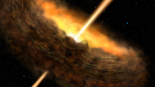
A New View of the Milky Way

More than a pretty picture, this panorama of cosmic scale reveals details that can help explain how massive stars are born and what’s feeding our Milky Way galaxy's supermassive black hole.
When Planets Collide

A double-star system that is more than 300 light-years away likely had an extreme collision between two of its rocky planets. A similar event in our own solar system may have formed our Moon.
How A Black Hole Feasts
Fear not, the dark, my friend. And let the feast begin! Magnetic fields in the Cygnus A galaxy are trapping material where it is close enough to be devoured by a hungry black hole.
Somewhere Like Home

The planetary system around Epsilon Eridani, a star located about 10 light-years away, has an architecture remarkably similar to our solar system. What’s more, its central star is a younger, fainter version of our Sun.
A Quiet Place

Black holes in many galaxies are actively consuming material, but our Milky Way galaxy’s central black hole is relatively quiet. Observations show magnetic fields may be directing material around, not into, the belly of the beast.
The Great Escape

Ever wonder how material leaves a galaxy? The wind flowing from the center of the Cigar Galaxy is so strong it's pulling a magnetic field — and the mass of 50 to 60 million Suns — with it.
Exploding Star, New Worlds

What happens when a star goes boom? It turns out that supernova explosions can produce a substantial amount of material from which planets like Earth can form.
Stellar Sibling Rivalry

They say siblings need time and space to grow, but here’s one that really needs some room. A newborn star in the Orion Nebula is clearing a bubble of space around it, preventing any new luminous family members from forming nearby.
Clues to Life’s Building Blocks

Radiation from stars is making organic molecules in nebula NGC 7023, also known as the Iris Nebula, larger and more complex. The growth of these molecules is one of the steps that could lead to the emergence of life under the right circumstances.
SOFIA is a modified Boeing 747SP aircraft that allows astronomers to study the solar system and beyond in ways that are not possible with ground-based telescopes. Find out more about the mission at www.nasa.gov/SOFIA.
Make sure to follow us on Tumblr for your regular dose of space: http://nasa.tumblr.com
Help us put the ART in Artemis! Our step-by-step draw Artemis guide will help you learn how to draw the space suit that will keep our astronauts safe during their trip to the Moon. Have fun, get creative and share your drawings using the hashtag #drawArtemis!
Make sure to follow us on Tumblr for your regular dose of space: http://nasa.tumblr.com
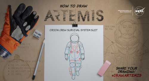
Do illustrations suit you? Then enjoy NASA at Home fun while learning to draw Orion’s Space Suit that will keep Astronauts safe during Artemis missions to the Moon! Visit https://go.nasa.gov/2SRacx2 for instructions and be sure to share your tailor-made suits to #drawARTEMIS
May the Four Forces Be With You!
May the force be with you? Much to learn you still have, padawan. In our universe it would be more appropriate to say, “May the four forces be with you.”
There are four fundamental forces that bind our universe and its building blocks together. Two of them are easy to spot — gravity keeps your feet on the ground while electromagnetism keeps your devices running. The other two are a little harder to see directly in everyday life, but without them, our universe would look a lot different!
Let’s explore these forces in a little more detail.
Gravity: Bringing the universe together

If you jump up, gravity brings you back down to Earth. It also keeps the solar system together … and our galaxy, and our local group of galaxies and our supercluster of galaxies.
Gravity pulls everything together. Everything, from the bright centers of the universe to the planets farthest from them. In fact, you (yes, you!) even exert a gravitational force on a galaxy far, far away. A tiny gravitational force, but a force nonetheless.

Credit: NASA and the Advanced Visualization Laboratory at the National Center for Supercomputing and B. O'Shea, M. Norman
Despite its well-known reputation, gravity is actually the weakest of the four forces. Its strength increases with the mass of the two objects involved. And its range is infinite, but the strength drops off as the square of the distance. If you and a friend measured your gravitational tug on each other and then doubled the distance between you, your new gravitational attraction would just be a quarter of what it was. So, you have to be really close together, or really big, or both, to exert a lot of gravity.
Even so, because its range is infinite, gravity is responsible for the formation of the largest structures in our universe! Planetary systems, galaxies and clusters of galaxies all formed because gravity brought them together.
Gravity truly surrounds us and binds us together.
Electromagnetism: Lighting the way
You know that shock you get on a dry day after shuffling across the carpet? The electricity that powers your television? The light that illuminates your room on a dark night? Those are all the work of electromagnetism. As the name implies, electromagnetism is the force that includes both electricity and magnetism.
Electromagnetism keeps electrons orbiting the nucleus at the center of atoms and allows chemical compounds to form (you know, the stuff that makes up us and everything around us). Electromagnetic waves are also known as light. Once started, an electromagnetic wave will travel at the speed of light until it interacts with something (like your eye) — so it will be there to light up the dark places.

Like gravity, electromagnetism works at infinite distances. And, also like gravity, the electromagnetic force between two objects falls as the square of their distance. However, unlike gravity, electromagnetism doesn't just attract. Whether it attracts or repels depends on the electric charge of the objects involved. Two negative charges or two positive charges repel each other; one of each, and they attract each other. Plus. Minus. A balance.
This is what happens with common household magnets. If you hold them with the same “poles” together, they resist each other. On the other hand, if you hold a magnet with opposite poles together — snap! — they’ll attract each other.
Electromagnetism might just explain the relationship between a certain scruffy-looking nerf-herder and a princess.
Strong Force: Building the building blocks

Credit: Lawrence Livermore National Laboratory
The strong force is where things get really small. So small, that you can’t see it at work directly. But don’t let your eyes deceive you. Despite acting only on short distances, the strong force holds together the building blocks of the atoms, which are, in turn, the building blocks of everything we see around us.
Like gravity, the strong force always attracts, but that’s really where their similarities end. As the name implies, the force is strong with the strong force. It is the strongest of the four forces. It brings together protons and neutrons to form the nucleus of atoms — it has to be stronger than electromagnetism to do it, since all those protons are positively charged. But not only that, the strong force holds together the quarks — even tinier particles — to form those very protons and neutrons.
However, the strong force only works on very, very, very small distances. How small? About the scale of a medium-sized atom’s nucleus. For those of you who like the numbers, that’s about 10-15 meters, or 0.000000000000001 meters. That’s about a hundred billion times smaller than the width of a human hair! Whew.
Its tiny scale is why you don’t directly see the strong force in your day-to-day life. Judge a force by its physical size, do you?
Weak Force: Keeping us in sunshine

If you thought it was hard to see the strong force, the weak force works on even smaller scales — 1,000 times smaller. But it, too, is extremely important for life as we know it. In fact, the weak force plays a key role in keeping our Sun shining.
But what does the weak force do? Well … that requires getting a little into the weeds of particle physics. Here goes nothing! We mentioned quarks earlier — these are tiny particles that, among other things, make up protons and neutrons. There are six types of quarks, but the two that make up protons and neutrons are called up and down quarks. The weak force changes one quark type into another. This causes neutrons to decay into protons (or the other way around) while releasing electrons and ghostly particles called neutrinos.
So for example, the weak force can turn a down quark in a neutron into an up quark, which will turn that neutron into a proton. If that neutron is in an atom’s nucleus, the electric charge of the nucleus changes. That tiny change turns the atom into a different element! Such reactions are happening all the time in our Sun, giving it the energy to shine.
The weak force might just help to keep you in the (sun)light.

All four of these forces run strong in the universe. They flow between all things and keep our universe in balance. Without them, we’d be doomed. But these forces will be with you. Always.
You can learn more about gravity from NASA’s Space Place and follow NASAUniverse on Twitter or Facebook to learn about some of the cool cosmic objects we study with light.
Make sure to follow us on Tumblr for your regular dose of space: http://nasa.tumblr.com
Making the Skies Safe for Unmanned Aircraft
Unmanned Aircraft Systems (commonly known as UAS or drones) are typically a smaller aircraft that fly without an onboard pilot. Currently used for research, testing, and aerial-visual purposes, these vehicles could one day carry cargo, or even passengers, through countryside and city landscapes.

UAS are a key component of our Unmanned Aircraft Systems Integration in the National Aairspace Ssystem (UAS in the NAS) project. Our research will help develop the rules so that unmanned aircraft can safely coexist with manned aircraft in the national airspace.

We collaborate with private companies, like Navmar Applied Science Corporation (NASC), to research and test aerodynamically efficient UAS. We also work with government agencies like the Federal Aviation Administration (FAA) to conduct research that will contribute to setting standards and certifications.

We are leading the nation to open a new era in air transportation called Advanced Air Mobility (AAM). AAM will enable safe, sustainable, affordable, and accessible aviation that moves people and cargo between places using a transformed air transportation system and revolutionary new aircraft.

With new cost-and-fuel efficient aircraft and technologies becoming available, UAS will provide substantial benefit to U.S. industry and the public. Such benefits include air-lifted organ transplant deliveries that arrive more quickly and safely than ever before; and search and rescue missions performed with increased speed and accuracy.

There are other benefits too, like pizza being air- dropped to your front door, and less package delivery trucks on the road. The burgeoning landscape of AAM holds many potentials – and it’s our job to help safely and sustainably map out and navigate what that future landscape looks like.
Want to learn the many ways that NASA is with you when you fly? Visit https://www.nasa.gov/aeronautics. Make sure to follow us on Tumblr for your regular dose of space: http://nasa.tumblr.com.
Get Ready To Launch America!

A new era of human spaceflight is about to begin. American astronauts will once again launch on an American rocket from American soil to the International Space Station as part of our Commercial Crew Program! NASA astronauts Bob Behnken and Doug Hurley will fly on SpaceX’s Crew Dragon spacecraft, lifting off on a Falcon 9 rocket at 4:32 p.m. EDT May 27, from Kennedy Space Center in Florida, for an extended stay at the space station for the Demo-2 mission.

As the final flight test for SpaceX, this mission will validate the company’s crew transportation system, including the launch pad, rocket, spacecraft and operational capabilities. This also will be the first time NASA astronauts will test the spacecraft systems in orbit.

Behnken and Hurley were among the first astronauts to begin working and training on SpaceX’s next-generation human space vehicle and were selected for their extensive test pilot and flight experience, including several missions on the space shuttle.

Behnken will be the joint operations commander for the mission, responsible for activities such as rendezvous, docking and undocking, as well as Demo-2 activities while the spacecraft is docked to the space station.

Hurley will be the spacecraft commander for Demo-2, responsible for activities such as launch, landing and recovery.

Lifting off from Launch Pad 39A atop a specially instrumented Falcon 9 rocket, Crew Dragon will accelerate its two passengers to approximately 17,000 mph and put it on an intercept course with the International Space Station. In about 24 hours, Crew Dragon will be in position to rendezvous and dock with the space station. The spacecraft is designed to do this autonomously but astronauts aboard the spacecraft and the station will be diligently monitoring approach and docking and can take control of the spacecraft if necessary.

The Demo-2 mission will be the final major step before our Commercial Crew Program certifies Crew Dragon for operational, long-duration missions to the space station. This certification and regular operation of Crew Dragon will enable NASA to continue the important research and technology investigations taking place onboard the station, which benefits people on Earth and lays the groundwork for future exploration of the Moon and Mars starting with the agency’s Artemis program, which will land the first woman and the next man on the lunar surface in 2024.
Get excited and follow along on social media using the hashtag #LaunchAmerica!
Make sure to follow us on Tumblr for your regular dose of space: http://nasa.tumblr.com.
Earth’s Land Ice by the Numbers
“At a glacial pace” used to mean moving so slowly the movement is almost imperceptible. Lately though, glaciers are moving faster. Ice on land is melting and flowing, sending water to the oceans, where it raises sea levels.

In 2018, we launched the Ice, Cloud and Land Elevation Satellite-2 (ICESat-2) to continue a global record of ice elevation. Now, the results are in. Using millions of measurements from a laser in space and quite a bit of math, researchers have confirmed that Earth is rapidly losing ice.
16 Years

ICESat-2 was a follow-up mission to the original ICESat, which launched in 2003 and took measurements until 2009. Comparing the two records tells us how much ice sheets have lost over 16 years.

½ Inch
During those 16 years, melting ice from Antarctica and Greenland was responsible for just over a half-inch of sea level rise. When ice on land melts, it eventually finds its way to the ocean. The rapid melt at the poles is no exception.

400,000 Olympic Swimming Pools
One gigaton of ice holds enough water to fill 400,000 Olympic swimming pools. It’s also enough ice to cover Central Park in New York in more than 1,000 feet of ice.

200 Gigatons
Between 2003 and 2019, Greenland lost 200 gigatons of ice per year. That’s 80 million Olympic swimming pools reaching the ocean every year, just from Greenland alone.

118 Gigatons
During the same time period, Antarctica lost 118 gigatons of ice per year. That’s another 47 million Olympic swimming pools every year. While there has been some elevation gain in the continent’s center from increased snowfall, it’s nowhere near enough to make up for how much ice is lost to the sea from coastal glaciers.

10,000 Pulses
ICESat-2 sends out 10,000 pulses of laser light a second down to Earth’s surface and times how long it takes them to return to the satellite, down to a billionth of a second. That’s how we get such precise measurements of height and changing elevation.

These numbers confirm what scientists have been finding in most previous studies and continue a long record of data showing how Earth’s polar ice is melting. ICESat-2 is a key tool in our toolbox to track how our planet is changing.
Make sure to follow us on Tumblr for your regular dose of space: http://nasa.tumblr.com.
Earth’s Land Ice by the Numbers
“At a glacial pace” used to mean moving so slowly the movement is almost imperceptible. Lately though, glaciers are moving faster. Ice on land is melting and flowing, sending water to the oceans, where it raises sea levels.

In 2018, we launched the Ice, Cloud and Land Elevation Satellite-2 (ICESat-2) to continue a global record of ice elevation. Now, the results are in. Using millions of measurements from a laser in space and quite a bit of math, researchers have confirmed that Earth is rapidly losing ice.

16 Years
ICESat-2 was a follow-up mission to the original ICESat, which launched in 2003 and took measurements until 2009. Comparing the two records tells us how much ice sheets have melted over 16 years.

½ Inch
During those 16 years, melting ice from Antarctica and Greenland was responsible for just over a half-inch of sea level rise. When ice on land melts, it eventually finds its way to the ocean. The rapid melt at the poles is no exception.

400,000 Olympic Swimming Pools
One gigaton of ice holds enough water to fill 400,000 Olympic swimming pools. It’s also enough ice to cover Central Park in New York in more than 1,000 feet of ice.

200 Gigatons
Between 2003 and 2019, Greenland lost 200 gigatons of ice per year. That’s 80 million Olympic swimming pools reaching the ocean every year, just from Greenland alone.

118 Gigatons
During the same time period, Antarctica lost 118 gigatons of ice per year. That’s another 47 million Olympic swimming pools every year. While there has been some elevation gain in the continent’s center from increased snowfall, it’s nowhere near enough to make up for how much ice is lost to the sea from coastal glaciers.

10,000 Pulses
ICESat-2 sends out 10,000 pulses of laser light a second down to Earth’s surface and times how long it takes them to return to the satellite, down to a billionth of a second. That’s how we get such precise measurements of height and changing elevation.

These numbers confirm what scientists have been finding in most previous studies and continue a long record of data showing how Earth’s polar ice is melting. ICESat-2 is a key tool in our toolbox to track how our planet is changing.
Make sure to follow us on Tumblr for your regular dose of space: http://nasa.tumblr.com.
21 Years of Amazing Earth Imagery
On April 29, 1999, NASA Earth Observatory started delivering science stories and imagery to the public through the Internet. Today, we turn 21! So much has changed in the past two decades...
One of the most notable changes is the way we view our home planet. Check out some of the beautiful imagery of our planet over the past 21 years.
2000: Pine Island Glacier

Most people will never see Pine Island Glacier in person. Located near the base of the Antarctic Peninsula—the “thumb” of the continent—the glacier lies more than 2,600 kilometers (1,600 miles) from the tip of South America. That’s shorter than a cross-country flight from New York to Los Angeles, but there are no runways on the glacier and no infrastructure. Only a handful of scientists have ever set foot on its ice.
This animation shows a wide view of Pine Island Glacier and the long-term retreat of its ice front. Images were acquired by the Moderate Resolution Imaging Spectroradiometer (MODIS) on our Terra satellite from 2000 to 2019. Notice that there are times when the front appears to stay in the same place or even advance, though the overall trend is toward retreat. Read more.
2002: The Blue Marble

In February 2002, Earth Observatory published this “blue marble” image based on the most detailed collection of true-color imagery of the entire Earth at that time. Using a collection of satellite-based observations, scientists and visualizers stitched together months of observations of the land surface, oceans, sea ice and clouds into a seamless, true-color mosaic of every square kilometer (.386 square mile) of our planet. Most of the information contained in this image came from Moderate Resolution Imaging Spectrometer (MODIS), illustrating the instrument's outstanding capacity to act as an integrated tool for observing a variety of terrestrial, oceanic and atmospheric features of the Earth. Read more.
2009: Tsauchab River Bed

The Tsauchab River is a famous landmark for the people of Namibia and tourists. Yet few people have ever seen the river flowing with water. In December 2009, an astronaut on the International Space Station caught this glimpse of the Tsauchab River bed jutting into the sea of red dunes. It ends in a series of light-colored, silty mud holes on the dry lake floor.
Like several other rivers around the Namib Desert, the Tsauchab brings sediment down from the hinterland toward the coastal lowland. This sediment is then blown from the river beds, and over tens of millions of years it has accumulated as the red dunes of the Namib Sand Sea. Read more.
2012: Manning Island and Foxe Basin, Canada

Although it may look like a microscope’s view of a thin slice of mineral-speckled rock, this image was actually acquired in space by the Earth Observing-1 satellite in July 2012. It shows a small set of islands and a rich mixture of ice in Foxe Basin, the shallow northern reaches of Hudson Bay.
The small and diverse sizes of the ice floes indicate that they were melting. The darkest colors in the image are open water. Snow-free ice appears gray, while snow-covered ice appears white. The small, dark features on many of the floes are likely melt ponds. Read more.
2013: A Lava Lamp Look at the Atlantic

Stretching from tropical Florida to the doorstep of Europe, this river of water carries a lot of heat, salt, and history. The Gulf Stream is an important part of the global ocean conveyor belt that moves water and heat across the North Atlantic from the equator toward the poles. It is one of the strongest currents on Earth, and one of the most studied.
This image shows a small portion of the Gulf Stream as it appears in infrared imagery. Data for this image was acquired on April 9, 2013, by the Thermal Infrared Sensor (TIRS) on the Landsat 8 satellite. TIRS observes in wavelengths of 10.9 micrometers and 12.0 micrometers. The image above is centered at 33.06° North latitude, 73.86° West longitude, about 500 kilometers (300 miles) east of Charleston, South Carolina. Read more.
2016: Curious Ensemble of Wonderful Features

When John Wesley Powell explored the Colorado River in 1869, he made the first thorough survey of one of the last blank spots on the map. The expedition began in May at Green River, Wyoming, and ended three months later at the confluence of the Colorado and Virgin Rivers in present-day Nevada.
About two months into their journey, the nine men of the expedition found themselves in Glen Canyon. As the men traveled along the serpentine river channel, they encountered what Powell later described in Canyons of Colorado as a “curious ensemble of wonderful features.”
From above, the view of Glen Canyon is equally arresting. In 2016, an astronaut aboard the International Space Station took several photographs that were combined to make a long mosaic. The water has an unnatural shade of blue because of sunglint, an optical phenomenon that occurs when sunlight reflects off the surface of water at the same angle that a camera views it. Click here to see the long mosaic.
2019: Lena Delta Shakes Off Water

For most of the year, the Lena River Delta—a vast wetland fanning out from northeast Siberia into the Arctic Ocean—is either frozen over and barren or thawed out and lush. Only briefly will you see it like this.
After seven months encased in snow and ice, the delta emerges for the short Arctic summer. The transition happens fast. The animation above, composed of images from the Moderate Resolution Imaging Spectroradiometer (MODIS) on our Aqua satellite, shows the transformation from June 3-10, 2019. Read more.
2020: Making Waves in the Andaman Sea

When tides, currents and gravity move water masses over seafloor features, they can create wave actions within the ocean. Oceanographers began studying these internal waves from ships in the 1960s, and the modern era of satellites has made it possible to see them on a grand scale. The Operational Land Imager (OLI) on Landsat 8 captured these images of the Andaman Sea on November 29, 2019. The reflection of the Sun on the ocean—sunglint—helps make the internal waves visible.
Internal waves form because the ocean is layered. Deep water tends to be colder, denser and saltier, while shallower water is often warmer, lighter and fresher. The differences in density and salinity cause layers of the ocean to behave like different fluids. When tides, currents, gravity and Earth’s rotation move these different water masses over seafloor formations (such as ridges or canyons), they create waves within the sea. Read more.
These images were taken from NASA Earth Observatory!
Interested in receiving Earth Observatory's Images of the Day? Subscribe to our newsletters or RSS feeds.
Make sure to follow us on Tumblr for your regular dose of space: http://nasa.tumblr.com.
Swift: Our Sleuth for the Universe’s Gamma-ray Bursts
The universe is full of mysteries, and we continue to search for answers. How can we study matter and energy that we can’t see directly? What’s it like inside the crushed core of a massive dead star? And how do some of the most powerful explosions in the universe evolve and interact with their surrounding environment?
Luckily for us, NASA’s Neil Gehrels Swift Observatory is watching the skies and helping astronomers answer that last question and more! As we celebrate its 15-year anniversary, let’s get you up to speed about Swift.

What are gamma-ray bursts and why are they interesting?
Gamma-ray bursts are the most powerful explosions in the universe. When they occur, they are about a million trillion times as bright as the Sun. But these bursts don’t last long — from a few milliseconds (we call those short duration bursts) to a few minutes (long duration). In the 1960s, spacecraft were watching for gamma rays from Earth — a sign of nuclear testing. What scientists discovered, however, were bursts of gamma rays coming from space!
Gamma-ray bursts eventually became one of the biggest mysteries in science. Scientists wanted to know: What events sparked these fleeting but powerful occurrences?
So how do gamma-ray bursts and Swift connect?
When it roared into space on a rocket, Swift’s main goals included understanding the origin of gamma-ray bursts, discovering if there were additional classes of bursts (besides the short and long ones), and figuring out what these events could tell us about the early universe.

With Swift as our eyes on the sky, we now know that gamma-ray bursts can be some of the farthest objects we’ve ever detected and lie in faraway galaxies. In fact, the closest known gamma-ray burst occurred more than 100 million light-years from us. We also know that these explosions are associated with some of the most dramatic events in our universe, like the collapse of a massive star or the merger of two neutron stars — the dense cores of collapsed stars.

Swift is still a powerful multiwavelength observatory and continues to help us solve mysteries about the universe. In 2018 it located a burst of light that was at least 10 times brighter than a typical supernova. Last year Swift, along with NASA’s Fermi Gamma-ray Space Telescope, announced the discovery of a pair of distant explosions which produced the highest-energy light yet seen from gamma-ray bursts.
Swift can even study much, much closer objects like comets and asteroids!

Why is Swift unique?
How do we study events that happen so fast? Swift is first on the scene because of its ability to automatically and quickly turn to investigate sudden and fascinating events in the cosmos. These qualities are particularly helpful in pinpointing and studying short-lived events.

The Burst Alert Telescope, which is one of Swift’s three instruments, leads the hunt for these explosions. It can see one-sixth of the entire sky at one time. Within 20 to 75 seconds of detecting a gamma-ray burst, Swift automatically rotates so that its X-ray and ultraviolet telescopes can view the burst.

Because of the “swiftness” of the satellite, it can look at a lot in 24 hours — between 50 and 100 targets each day! Swift has new “targets-of-opportunity” to look at every day and can also look at objects for follow up observations. By doing so, it can see how events in our cosmos change over time.
How did Swift get its name?
You may have noticed that lots of spacecraft have long names that we shorten to acronyms. However, this isn’t the case for Swift. It’s named after the bird of the same name, and because of the satellite’s ability to move quickly and re-point its science instruments.
When it launched, Swift was called NASA’s Swift Observatory. But in January 2018, Swift was renamed the Neil Gehrels Swift Observatory in memory of the mission’s original principal investigator, Neil Gehrels.

Follow along with Swift to see a typical day in the life of the satellite:
Game Time: Final Voting for Tournament Earth
The moment has arrived- it's time to decide the NASA Earth Observatory's all-time best image. After four grueling rounds of voting, two contenders remain: Ocean Sand, Bahamas (#5 seed) versus Raikoke Erupts (#6 seed).

The road to the finals has been full of surprises. All top seeds have been knocked out. In one semifinal, Ocean Sand garnered 50.6 percent of the votes to squeak out a win over the overall favorite, Twin Blue Marbles. In the other matchup, Raikoke Erupts trounced Where the Dunes End, 66.5 to 33.5 percent.
Now you have to pick a champion. Will it be a gorgeous, artistic image from the very early years of Earth Observatory or stunning natural-color views of an explosive event from 2019? Which image will you crown as the best in the EO archives: Ocean Sand, Bahamas or Raikoke Erupts? Voting ends on April 28 at 9 a.m. U.S. Eastern Time.
Thank you for helping us celebrate Earth Observatory’s 20th anniversary and the 50th anniversary of Earth Day!
Vote here: https://earthobservatory.nasa.gov/tournament-earth
Make sure to follow us on Tumblr for your regular dose of space: http://nasa.tumblr.com.
How do you guys help with climate change?

That’s a wrap! Thank you all so much for your awesome questions!
If you’re looking for other ways to enjoy #EarthDayatHome, check out this feature: https://www.nasa.gov/feature/goddard/2020/earthdayathome-with-nasa/
Don’t forget to follow NASA Earth on Twitter, Facebook and Instagram.
You can follow Sandra Cauffman on Twitter, HERE.
You can follow Dr. Thomas Zurbuchen “Dr. Z” on Twitter, HERE.
Happy Earth Day!
How is it like to be a NASA Earth Scientist? What Subjects are you required to excel at to become one? Were you really good in your studies, when you were a young teenager?
What are the different fields of Earth Science? Are they related to each other?
What’s your favorite geological feature to view from space? Alternatively, what’s the biggest “duh” moment you’ve had during your career where you had an incorrect, preconceived notion about something. Thanks!
When you first saw Earth from all the way up in space, what were your first thoughts? Did it change the way you viewed things?
What ways were used to determine all of the inner workings under our planet Earth’s surface?
Whats the coolest thing u have seen or discovered???!!!! Like i mean cool as in something that made u nerd out! I used to want to work for nasa but found a love for teaching art instead so i find myself nersing out over the cool research yall put out! Much love from wise county texas!
In recent years of tracking weather activity and the like, have there been more 'anomolies' that have stuck out more than others? (I.E hurricanes, typhoons or cyclones that start out as small storms then become hurricane 4-5 storms in a matter of days-weeks) I think what you guys are doing is awesome and keep up the good work ~TKL
How did you decide to scientist? How you start works? And what did you do for that ?
Question: How did you decide to be a scientist? How did you start work? And what did you do for that?
Hi there! Does the study of Earth Science teach us much about the science of other planets? Can much be assumed to be similar, or is the geology/biology incomparable? Thank you!
Are the rumors about the ozone layer being totally fixed true ? If yes , is it susceptible of being opened again ans if no, is it suspecte
Has the COVID-19 pandemic really reduced pollution in areas participating in lockdowns? Is the environment “recovering”?
How do you guys help with climate change?
Hello! I have always wondered about how the clouds work, it seems like they are just gas in the air, but what makes them appear so often? Or how do they form? And how and why do the block out the sun if they're just air?
What was your favourite NASA mission or project?
Follow our Mars 2020 rover, named Perseverance or “Percy,” on Twitter to keep up with all its progress and discoveries!
Percy: https://twitter.com/NASAPersevere
How can citizens become more involved and informed about Earth sciences and developments? Are there mailing lists or accounts you suggest following?
Website: https://science.nasa.gov/citizenscience
What are three things you would want everyone to know about your work?
Is your only job helping astronauts and satellites or does NASA do other thing too?